
Who We Are | Our Facilities | Grounds | History | Becoming a River Pilot | Ships We Pilot | River Facts
Who We Are
Columbia River Pilots are an association of 45+ professional mariners licensed by the State of Oregon to provide maritime pilotage services to all ports on the lower Columbia and Willamette Rivers. Our pilots possess extensive navigational experience, local knowledge and ship-handling skills and are charged with safely and efficiently piloting vessels in all weather conditions, at all hours of the day and night, 365 days a year.
Our Facilities
Our headquarters is located in the Rivergate District of North Portland. River pilots are dispatched from this facility where all vessel activities are tracked and coordinated as they arrive, anchor, shift between berths or depart. Monitoring ships via AIS, our pioneering Vessel Traffic Information System allows the Pilots to provide the entire industry with a centralized source for real time information on vessel location and operations. Our Pilot Station is located on the Astoria waterfront at the foot of 14th Street. This historic facility provides moorage for our pilot boats, the Connor Foss & the Swift, and sleeping quarters for Pilots awaiting inbound ship assignments.
The Columbia and Willamette Pilotage Grounds
Columbia River Pilots are licensed to pilot over 320 nautical miles of the Columbia River from Astoria to the Ports of Longview, Kalama, Vancouver, Portland, The Dalles and Pasco. We also provide pilotage service on 13 miles of the Willamette River from its mouth to the seawall in downtown Portland. This route is considered by many to be one of the most lengthy and challenging pilotage grounds in the world. The Columbia River navigation channel is a narrow and winding channel subject to strong currents, shifting shoals and inclement weather. The channel is maintained to project depth of 43 feet and width of 600 feet. The distance between the Astoria Pilot Station and the Ports of Portland and Vancouver is 75 nautical miles. The longest straight stretch of river is only about 2 miles in length and there are over 90 course changes between Astoria and the Portland Downtown Sea Wall.
History – Pilotage in Oregon
The earliest records of a licensing board in Oregon are the laws applying to bar and river pilots. Piloting first became a major concern in Oregon in 1846 when an unqualified seaman offered his pilotage services on the treacherous Columbia River Bar. The vessel grounded within twenty minutes. Appointment of the first pilot board was authorized by Oregon Territorial Legislature in December, 1846. Since 1899, the governor has made appointments to the board, which is currently comprised of nine individuals: three public members, three pilot members, and three maritime industry representative members. The combination of these three groups brings a balanced perspective to board decision-making. The Board of Maritime Pilots acts today as a professional licensing and regulatory agency whose primary consideration is public safety.
Becoming a Columbia River Pilot
The piloting profession is widely considered the pinnacle of a maritime career. In Oregon, Pilot Trainees are selected by the Oregon Board of Maritime Pilots. Candidates for the Training Program must have Federal Pilotage for the Columbia and Willamette Rivers and a minimum of three-years experience as captain of a towboat operating on the Columbia and Willamette Rivers. For candidates without the requisite river experience, the Oregon Board of Maritime Pilots also administers an Apprenticeship Training Program. Those selected must complete a rigorous two and one-half year training program to become a fully licensed Columbia River Pilot. For more information on the Columbia River Pilots Training and Apprenticeship Programs please visit the Oregon Board of Maritime Pilots website.
Ships We Pilot
Articulated Tug And BargeATB’s consist of a large tugboat connected into the notch of a tank barge. A ‘hinged’ coupling allows the tug to detach from the barge when necessary and operate as a separate unit. ATB’s differ from an Integrated Tug and Barge (ITB) which has a rigid, semi-permanent connection. |
 |
Car CarrierPCC’s or Pure Car Carriers have large ramps either amidships or at the stern to allow easy loading and off-loading of cars. |
 |
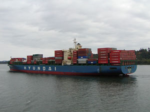
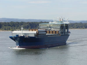
Container ShipThe largest ships currently calling at the Port of Portland, these vessels often exceed 900 feet in length and are capable of carrying over 5000 TEU’s (twenty-foot equivalent units) of containers. Most are post-Panamax size ships with a beam of over 132 feet. |
 |
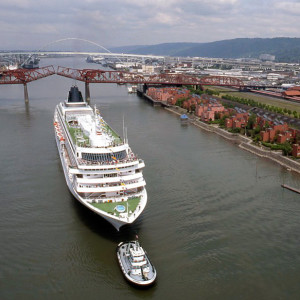
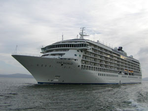
Cruise ShipWhen visiting with passengers, these ships berth at the sea wall in downtown Portland or at the Port of Portland’s Terminal 2. They also will stop at Swan Island for drydocking and repair. |
 |
Open Hatch Cargo ShipIdentified by their large gantry cranes, these ships carry everything from general cargo to windmill towers. |
 |
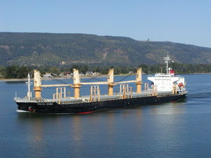
General Cargo ShipOften smaller vessels, these crane equipped ships haul bulk commodities, break bulk cargos and logs. |
 |
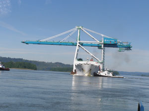
Heavy Lift ShipUsed for oversize cargos these semi-submersible vessels can transport other ships and container cranes like the one delivered to the Port of Portland. |
 |
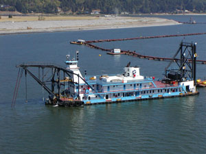
Hopper DredgeDredges such as the Corp of Engineer’s ‘Essayons’ help maintain the navigation channel by removing sand from the river bottom and placing it aboard in a hopper that can be opened for discharge at another location. |
 |
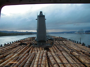
Log CarrierThese are bulk cargo carriers set up specifically to transport logs. |
 |
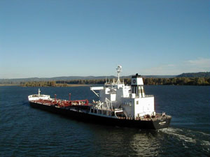
Oil TankerAlthough no crude oil is transported on the Columbia River other petroleum products such as diesel, jet fuel, asphalt and gasoline are hauled in these tankers. The largest tankers are called VLCC’s or Very Large Crude Carrier. |
 |
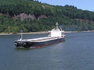
Panamax Size Bulk CarrierSo named because their beam of 106 feet is the maximum allowed width for passage through the Panama Canal, these bulk carriers transport much of the grain shipments from the Willamette and Columbia Rivers. |
 |
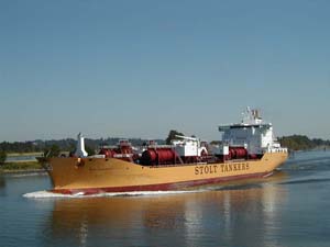
Product TankerThese tankers carry of variety of specialty products such as edible oils or chemicals. |
 |
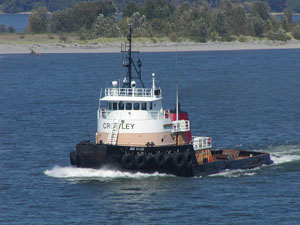
Sea Going TugSmall but powerful these boats tow everything from petroleum products, scrap cars, wood chips and limestone to containers and large machinery. They can be seen either towing barges behind on a tow line or made-up to the stern of the barge and pushing it. |
 |
Suction DredgeUnlike a hopper-type, dredges such as the Port of Portland’s Dredge OREGON maintain the channel by removing sand and pumping it to near-by locations for either in-water or shore-side disposal. |
 |
River Facts
Metrics
| Source: | British Columbia |
| Elevation: | 2,690 feet (820 m) |
| Length: | 1,243 miles (2,00 km) |
| Basin: | 258,000 sq miles (668.00 sq km) |
| Average Flow: | 265,000 cu ft/s (7,50 cu m/s) |
| Max Flow: | 1,240,000 cu ft/s (35,100 cu m/s) |
| Channel Depth: | 43 feet (12-13 m) Astoria to Portland |
| Number of dams: | 14 dams (on main stem) |
Major Tributaries
| Snake River | 56,900 cu ft/s (1,610 cu m/s) |
| Willamette River | 37,400 cu ft/s (1,060 cu m/s) |
| Kootenay River (Kootenai) | 30,650 cu ft/s (868 cu m/s) |
| Pend Oreille River | 26,430 cu ft/s (748 cu m/s) |
| Cowlitz River | 9,140 cu ft/s (259 cu m/s) |
| Spokane River | 7,900 cu ft/s (224 cu m/s) |
| Lewis River | 6,125 cu ft/s (173 cu m/s) |
| Deschutes River | 5,845 cu ft/s (166 cu m/s) |
| Wenatchee River | 3,079 cu ft/s (87 cu m/s) |
| Okanogan River | 3,039 cu ft/s (86 cu m/s) |
| Kettle River | 2,925 cu ft/s (83 cu m/s) |
| Sandy River | 2,257 cu ft/s (64 cu m/s) |
| John Day River | 2,060 cu ft/s (58 cu m/s) |